 |
 |
 |
 |
 |
 |
| |
 |
|
 |
 |
 |
  |
  |
 |
 |
 |
 |
|
|
 |
|
 |
 |
 |
BUILDING |
 |
|
 |
|
 |
 |
 |
| |
 |
| 
 |
Parque lineal de La Sagrera
La Sagrera Linear Park |
|
 |
 |
 |
 |
DESIGNER |
 |
|
|
 |
|
 |
 |
 |
| |
 |
|
 |
 |
 |
 |
DESCRIPTION |
 |
|
|
 |
|
 |
 |
 |
|
|
 |
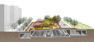
 A new green diagonal axis extends into the very heart of XXI century Barcelona. It is a natural path for pedestrians and bicycles as protagonists of a new era of a greener and more habitable metropolis, which is in direct contact with its natural surroundings. The initiative is a key to improve biodiversity and a stronger urban ecological role of the city. A new green diagonal axis extends into the very heart of XXI century Barcelona. It is a natural path for pedestrians and bicycles as protagonists of a new era of a greener and more habitable metropolis, which is in direct contact with its natural surroundings. The initiative is a key to improve biodiversity and a stronger urban ecological role of the city.
 El Camí Comtal will finally connect the Sea and the Mountains, Nature and City in Barcelona. It strengthens the landscape experience for those approaching the sea from the coastal range through the city. It offers a unique opportunity to unimpeded travel from the wildest Catalan Pyrenees to the heart of its capital city. This green track enters the city through the Besós natural valley finding continuity in the new Cami Comtal park or La Sagrera linear park. A generous shaded way for pedestrians, bicycles and skaters who will discover the different environments through Sant Andreu and Sant Marti neighbourhoods, El Clot park, historical gardens of Ciutadella to finally end up at the sea. El Camí Comtal will finally connect the Sea and the Mountains, Nature and City in Barcelona. It strengthens the landscape experience for those approaching the sea from the coastal range through the city. It offers a unique opportunity to unimpeded travel from the wildest Catalan Pyrenees to the heart of its capital city. This green track enters the city through the Besós natural valley finding continuity in the new Cami Comtal park or La Sagrera linear park. A generous shaded way for pedestrians, bicycles and skaters who will discover the different environments through Sant Andreu and Sant Marti neighbourhoods, El Clot park, historical gardens of Ciutadella to finally end up at the sea.
El Parc del Camí Comtal gives a breath to the bustling city of Cerdá, introducing a new green SLOW cross as a counterpoint to today’s urban frenzy and activity represented by the other Diagonal. It is also a milestone track where landscapes, architecture, history and the installation of water fountains enrich its tour and make a memorial to the old Rec Comtal infrastructure that was carrying once the natural water resource to the city.
The visitor who arrives to the new Parc del Cami Comtal either by train from elsewhere in Europe, by bike from the mountains, or on foot or by public transport from the city, will experience the benefits of a green welcome carpet to the city replacing the old iron scar where the new La Sagrera linear park reflects the identity of its historical neighborhoods, allowing at the same time, an optimum green connection between landscape and city. |
|
 |
 |
 |
 |
 |
 |
 |
LOCATION |
 |
|
|
 |
|
 |
 |
 |

|
 |

|
Continent |
|
 |
|
Nation |
|
 |
|
Autonomous community |
|
 |
|
Province |
|
 |
|
Town |
|
 |
|
Neighborhoods |
|
 |
|
|
|
 |
|
 |
 |
 |
 |
MAP |
 |
|
|
 |
|
 |
 |
 |
| |
 |
|
 |
 |
 |
 |
|
TYPOLOGY |
 |
|
|
 |
|
 |
 |
 |
|
|
 |
LANDSCAPE ARCHITECTURE AND NATURAL ENVIRONMENTS | Landscape architecture
Public parks
Mitigation of infrastructures
|
TOWN PLANNING AND URBAN DESIGN | Urban design and urban renovation
Areas and infrastructures for transport
| |
 |
 |
 |
 |
CHRONOLOGY |
 |
|
|
 |
|
 |
 |
 |
Project |
 |
|
 |
| 
 |
2011 - 2012
project winner of competition
|
|
Realisation |
 |
|
 |
| 
 |
2012 - 2015 |
|
 |
 |
 |
 |
BIBILIOGRAPHIC REFERENCES |
 |
|
|
 |
|
 |
 |
 |
|
 |
| Genis Pascual i Porret, "Mancances al Pla de Sant Andreu-Sagrera/Shortcomings of the Sant Andreu-La Sagrera Plan", Quaderns d'arquitectura i urbanisme 254, verano/summer 2007, pp. 173-175 |
|
 |
 |
 |
 |
 |
 |
 |
CLIENT |
 |
|
|
 |
|
 |
 |
 |
| |
 |
BSAV, Barcelona Sagrera Alta Velocitat s.a.
National ministry of infrastructures
Adif
Renfe
Government of Catalunya
City council of Barcelona |
|
 |
 |
 |
 |
DIMENSIONAL
DATA |
 |
|
|
 |
|
 |
 |
 |
| Surface |
 |
|
 |
|
 |
 |
 |
 |
STRUCTURES |
 |
|
|
 |
|
 |
 |
 |
| |
 |
|
 |
 |
 |
 |
LANDSCAPE DESIGN |
 |
|
|
 |
|
 |
 |
 |
| |
 |
|
 |
 |
 |
 |
STAFF |
 |
|
|
 |
|
 |
 |
 |
Project  |
 |
|
|
 |
|
|
 |
|
Engineering |
 |
|
Botanical consultant |
 |
|
Lighting design |
 |
|
Transport planning |
 |
|
Graphics and signage |
 |
|
 |
 |
 |
 |
CREDITS |
 |
|
|
 |
|
 |
 |
 |
| |
 |
Images © West 8
Text edited by West 8
Courtesy of West 8
|
|
 |
  |
 |
|
|